Following Antietam Battle Action with Maps
This page will show you where the opposing forces moved and clashed on September 17, 1862 near Sharpsburg, Maryland.
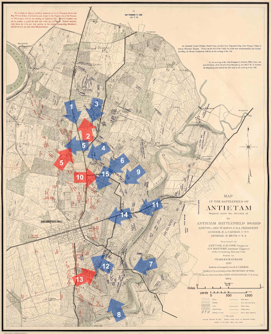
The map below locates and highlights the main assaults during the day. The arrows represent large bodies of troops - generally units at the Division and Army Corps/Wing levels - and their approximate locations and direction of attack. Click on any arrow to see a much more detailed map which shows positions down to the regiment and battery levels. Each detail map also provides further links to data for individual units and commanders.
You might like also to refer to the map on our Overview page which labels many of the most significant landmarks on the battlefield, and shows the same area as this map. We're covering a lot of ground here, so the scale gets fairly small, and it can be hard to see details.
See more about ... the maps used here on AotW.
Antietam Battle Maps available:
- Detail Map 1 Hookers First Corps Sweeps Down the Hagerstown Pike (5-7 am) [map time: 7:00 O'Clock A.M., 17 September 1862]
- Detail Map 2 Hood's Division Retakes Miller's Cornfield (7-8 am) [map time: 7:20 O'Clock A.M., 17 September 1862]
- Detail Map 3 Mansfield's Twelfth Corps Attacks into Miller's Cornfield (7-9 am) [map time: 8:40 O'Clock A.M., 17 September 1862]
- Detail Map 4 Greene's High-Water Mark in the West Woods (9am-noon) [map time: 10:30 O'Clock A.M., 17 September 1862]
- Detail Map 5 Sedgwick is Flanked in the West Woods (9-10am) [map time: 9:30 O'Clock A.M., 17 September 1862]
- Detail Map 6 French's Division Hits the Sunken Road (9-10 am) [map time: 9:00 O'Clock A.M., 17 September 1862]
- Detail Map 7 Burnside Attacks the Lower Bridge (10 am-1 pm) [map time: 12:00 O'Clock Noon, 17 September 1862]
- Detail Map 8 Rodman's Division Crosses at Snavely's Ford (10 am-1 pm) [map time: 1:00 O'Clock P.M., 17 September 1862]
- Detail Map 9 Richardson's Division Attacks the Sunken Road (10-11 am) [map time: 10:30 O'Clock A.M., 17 September 1862]
- Detail Map 10 Confederate Counterattacks in the Center (11 am-1 pm) [map time: 12:15 O'Clock P.M., 17 September 1862]
- Detail Map 11 Sykes' Regulars Advance from the Middle Bridge (noon-4 pm) [map time: 1:00 O'Clock P.M., 17 September 1862]
- Detail Map 12 Burnside's Ninth Corps Climbs Toward Sharpsburg (3-4 pm) [map time: 3:30 O'Clock P. M., 17 September 1862]
- Detail Map 13 AP Hill's Division Hits Burnside's Flank (4-5 pm) [map time: 4:20 O'Clock P. M., 17 September 1862]
- Detail Map 14 Sykes' Regulars Near Sharpsburg (4-5 pm) [map time: 5:00 O'Clock P.M., 17 September 1862]
- Detail Map 15 The Charge of the 7th Maine at Piper's Farm (5-5:30 pm) [map time: 5:00 O'Clock P. M., 17 September 1862]
 Open main menu