 Open main menu
Open main menu
Open main menu
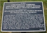
Typical Tablet (#347):
Drayton's Brigade , Jones' Division, Antietam, c.1897
During the 1890's the members of the Antietam Battlefield Board had produced more than 200 cast iron historical tablets - explanatory markers - and placed them along the roadways of the new National Battlefield to mark position and movements of all the Brigades at Antietam (see locating maps).
Most of the tablets are still in place today, and serve as an excellent on-the-spot guide to the details of the ebb and flow of combat. We've stored the full text and locations of all of the original Tablets here on AotW; see the complete list on the Tablet Index page.
The present day Park had it's beginnings before the end of the Civil War, when, in March 1864, Maryland legislators appropriated funds to establish a cemetery near Sharpsburg as permanent resting place for the bodies of Federal troops killed there. Between that time and 1877, the Board of the Antietam National Cemetery, made up of representatives from Maryland and other Union states, planned, funded, built, and maintained the Cemetery on land purchased for the purpose from farmer John F. Kennedy.
Some 4,667 soldiers had been interred there by September 1867, when the Cemetery was formally dedicated. It's maintenance and upkeep became the responsibility of the Quartermaster Corps, US War Department, by act of Congress, effective August 1879.1
Acts of Congress of August 1890 authorized the first two US national battlefield parks: Chickamauga and Chattanooga National Park (19 Aug) and Antietam National Battlefield Site (30 Aug). The stated purpose of the legislation was to survey and mark the lines of battle for both Armies at Antietam, the positions of the Regular Army units there, and to buy land and build roads and drives to access those markers.2
The park was to ensure a "clear understanding of the field and illustrate, for historical purposes, the unparalleled deadly fighting which distinguishes it above all others" and, as "the field on which the battle took place is practically unchanged from what it was on the day of the action [...] it is proposed to maintain the field in the same condition as to roads, fields, forests, and houses." 3
To do all this, in 1891 the War Department appointed a two (later four) man board, the Antietam Battlefield Board, to do the research and plot and mark the lines and positions as called for by Congress.
Colonel John Stearns, a Vermont veteran, appointed President, and General Harry Heth of Virginia were the original Board members. Between 1891 and 1894, though crippled somewhat my meager resources and periods of illness, they compiled official records, corresponded with veterans of the battle, and produced basic maps of the lines of battle at Sharpsburg. They also put up temporary wooden markers noting positions of most of the units, as they were able to determine them, but had not yet procured any land on which to build roads and mount permanent markers.
In October 1894, Colonel Stearns resigned due to poor health. General Ezra Carman, formerly Colonel 13th New Jersey, who had been a trustee of the Cemetery (1866-77) and an unsuccessful candidate for the Board in 1891, applied for the open position. He was appointed as "historical expert" on the Board. Later in the month, the QMC turned over supervision of the effort to the Secretary of War, who almost immediately expanded the Board by two new members: Jedediah Hotchkiss, as "expert topographer", and Major George B. Davis, Army Judge Advocate, as the new President.4
Except for a period (Aug 95 - Jun 96) when they were disbanded for lack of funds, this dynamic Board did extensive research, verified by official records and review by veterans, and wrote the history of the battle through the text to be used on the tablets. With engineering help from members of the Gettysburg team, they also produced the set of 14 maps which are today the definitive study of positions and movements of the units at the battle, published later as the Atlas of Antietam . 5
It was Major Davis' idea that Antietam could best be preserved by leaving the bulk of the land in the hands of local farmers to maintain it as it had been since 1862, and that the Government needed to buy only small areas of land to mark battle lines, mount markers, and give access to the site. He also proposed the stone observation tower which was later built on the Sunken Road. The Secretary of War agreed with his approach. Between April and July 1895 the Board acquired most of the strips and parcels of land on which the tablets and roads would be constructed, and by August that year the tablets were being cast at Chattanooga. At that time George B. Davis transferred to a new assignment and was replaced by Major George W. Davis, an engineer and Antietam veteran.6
25 additional Historical Tablets were specified in mid-1896. By July 1897 the 217 tablets of Antietam were installed, along with the 25 more at the other battle sites of the Maryland Campaign, the roads built, and the tower in place. Along with 170 iron 'locality' and 'guide' markers, the Historical Tablets had cost about $6,400 to produce. In early 1898 the final work of the board, the official map of the lines of battle, was completed, and the Antietam Battlefield Board was officially disbanded by the Secretary of War.7
As recently as 1952 215 of the 217 Antietam historical tablets were in place, needing only occasional repainting for maintenance to remain in service. A major threat to the tablets since the 1930's has been damage from cars; by the 1990's at least 25 of the tablets had gone missing - some likely to vandalism reported in the late 1960's.8 The Park Service has expressed interest in replacing these tablets as funding can be found.9
There are at least three collections of research materials, correspondence, and manuscripts associated with the Battlefield Board. These are a magnificent source of detailed information about the Battle, and we'll dig into them as the opportunity presents:
See more about ... Tablet text and locations from the Tablet Index list.
1 Snell, Charles W., and Sharon A. Brown, Antietam National Battlefield and National Cemetery: An Administrative History, Washington DC: US Department of the Interior/National Park Service, 1986, pp. 1-16 [AotW citation 67]
2 US House of Representatives, Appropriations Bill, Antietam, H.R. 10884, Washington DC: 51st Congress, 1st Session, 1890 [AotW citation 68]
3 US House of Representatives, Report 4019, Washington DC: Committee on Military Affairs, 1891, pp. 1-3 [AotW citation 69]
4 Snell & Brown, pp. 73-86 [AotW citation 70]
5 Carman, Ezra Ayres, and Lieut. Col. Emmor B. Cope, Hays W. Mattern, Charles H. Ourand, Atlas of the Battlefield of Antietam, 14 maps, Washington DC: US Government Printing Office, 1908 [AotW citation 76]
6 Snell & Brown, pp. 94-101 [AotW citation 77]
7 Snell & Brown, pp. 106-113 [AotW citation 78]
8 Snell & Brown, pp. 164, 258, 407 [AotW citation 79]
9 Large, George R., and Joe A. Swisher, Battle of Antietam: The Official History by the Antietam Battlefield Board, Shippensburg (Pa): Burd Street Press, 1998, pg. xi [AotW citation 80]