 Open main menu
 Open main menu

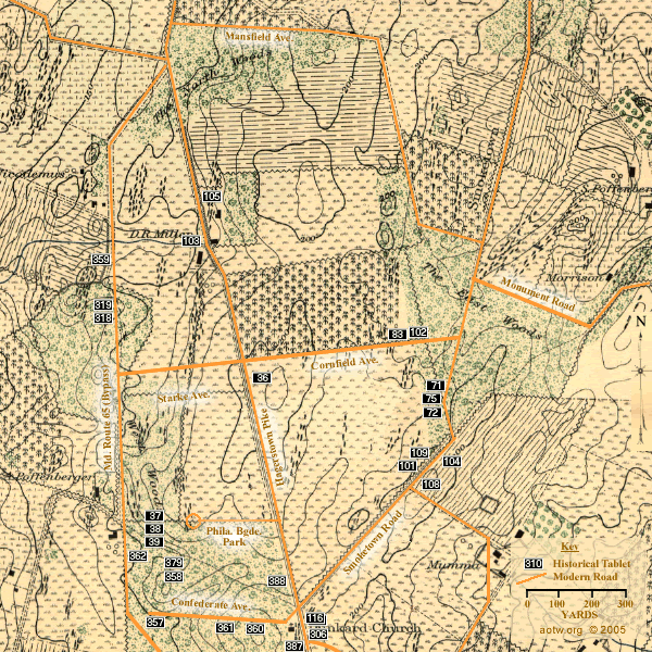
Click on a numbered tablet symbol above to see a representation of that tablet's text
See ... the previous map in this sequence (Map 1 - Northern Part of the Field )
See ... the next map in this sequence (Map 3 - Central Part of the Field )
See more about ... the maps on AotW
36 - Sedgwick's Division, Second Army Corps - east side of the Hagerstown Pike near Cornfield Avenue
37 - Gorman's Brigade, Sedgwick's Division - east side of the Maryland Rt. 65 bypass, north of Confederate Avenue
38 - Dana's Brigade, Sedgwick's Division - east side of the Maryland Rt. 65 bypass, north of Confederate Avenue
39 - Howard's Brigade, Sedgwick's Division - east side of the Maryland Rt. 65 bypass, north of Confederate Avenue
71 - Slocum's Division, Sixth Army Corps - north side of the Smoketown Road north of the Mumma Farm Lane
72 - Smith's Division, Sixth Army Corps - north side of the Smoketown Road north of the Mumma Farm Lane
75 - Irwin's Brigade, Smith's Division - north side of the Smoketown Road north of the Mumma Farm Lane
83 - U.S. Artillery - north side of Cornfield Avenue near the East Woods
101 - Batteries A and C, 4th U.S. Artillery - north side of the Smoketown Road near Mumma Farm Lane
102 - Sixth Army Corps - north side of Cornfield Avenue near the East Woods
103 - Battery B, 4th U.S. Artillery - west side of the Hagerstown Pike south of the North Woods
104 - Battery D, 2d US Artillery - south side of the Smoketown Road near Mumma Farm Lane
105 - Battery C, 5th U.S. Artillery - east side of the Hagerstown Pike on the Miller Farm
108 - Battery F, 5th U.S. Artillery - south side of the Smoketown Road near Mumma Farm Lane
109 - Battery I, 1st U.S. Artillery - north side of the Smoketown Road near Mumma Farm Lane
116 - Second Army Corps - east side of the Hagerstown Pike opposite the Dunkard Church
306 - Reserve Artillery, Longstreet's Command - east side of the Hagerstown Pike near the Smoketown Road
318 - Hampton's Brigade, Stuart's Cavalry Division - west side of the Maryland Rt. 65 bypass, north of Confederate Avenue
319 - Lee's Brigade, Stuart's Cavalry Division - west side of the Maryland Rt. 65 bypass, north of Confederate Avenue
357 - McLaws' Division, Longstreet's Command - south side of Confederate Avenue
358 - Barksdale's Brigade, McLaws' Division - west side of the Philadelphia Brigade Park
359 - Semmes' Brigade, McLaws' Division - west side of the Maryland Rt. 65 bypass, north of Confederate Avenue
360 - Walker's Division, Longstreet's Command - south side of Confederate Avenue
361 - Kershaw's Brigade, McLaws' Division - south side of Confederate Avenue
362 - Ransom's Brigade, Walker's Division - east side of the Route 65 bypass, south of Starke Avenue
379 - Early's Brigade, Ewell's Division - west side of the Philadelphia Brigade Park
387 - Kershaw's Brigade, McLaws' Division - west side of the Hagerstown Pike south of the Dunkard Church
388 - Manning's Brigade, Walker's Division - west side of Hagerstown Pike, north of the Smoketown Road