 Open main menu
Open main menu
Open main menu
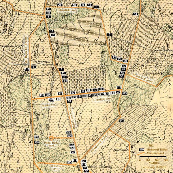
Click on a numbered tablet symbol above to see a representation of that tablet's text
See ... the next map in this sequence (Map 2 - Northern Part of the Field )
See more about ... the maps on AotW
1 - First Army Corps - north side Mansfield Avenue, north of the North Woods
2 - Doubleday's Division, First Army Corps - east side of the Hagerstown Pike, west edge of the Cornfield
3 - Doubleday's Division, First Army Corps - east side of the Hagerstown Pike, south of Miller's house
4 - Hofmann's Brigade, Doubleday's Division - east side of the Hagerstown Pike, north of the North Woods
5 - Patrick's Brigade, Doubleday's Division - east side of the Route 65 bypass, north of Starke Avenue
6 - Gibbon's Brigade, Doubleday's Division - north side of Starke Avenue near the Hagerstown Pike
7 - Ricketts' Division, First Army Corps - east side of Mansfield Avenue between the North and West Woods
8 - Duryea's Brigade, Ricketts' Division - north side of Cornfield Avenue
9 - Christian's Brigade, Ricketts' Division - north side of Cornfield Avenue
10 - Hartsuff's Brigade, Ricketts' Division - north side of Cornfield Avenue
11 - Meade's Division, First Army Corps - north side of Mansfield Avenue, north of the North Woods
12 - Magilton's Brigade, Meade's Division - east side of the Hagerstown Pike just south of the North Woods
13 - Doubleday's Division, First Army Corps - west side of the Hagerstown Pike, north of the North Woods
14 - Ricketts' Division, First Army Corps - west side of the Smoketown Road about 500 yards north of the East Woods
15 - Meade's Division, First Army Corps - north side of Mansfield Avenue, north of the North Woods
16 - Magilton's Brigade, Meade's Division - north side of Mansfield Avenue, north of the North Woods
17 - Seymour's Brigade, Meade's Division - west side of Smoketown Road at the north edge of the East Woods
20 - Goodrich's Brigade, Greene's Division - east side of the Hagerstown Pike at the Cornfield
24 - Anderson's Brigade, Meade's Division - north side of Mansfield Avenue, north of the North Woods
25 - Doubleday's Division Artillery - west side of Hagerstown Pike, north of the North Woods
27 - Twelfth Army Corps - north side Mansfield Avenue near the Smoketown Road
28 - Williams' Division, Twelfth Army Corps - north side of Mansfield Avenue near the Smoketown Road
29 - Crawford's Brigade, Williams' Division - north side of Mansfield Avenue near the Smoketown Road
31 - Anderson's Brigade, Meade's Division - east side of the Hagerstown Pike at the south edge of the North Woods
32 - Phelps' Brigade, Doubleday's Division - north side of Cornfield Avenue
36 - Sedgwick's Division, Second Army Corps - east side of the Hagerstown Pike near Cornfield Avenue
48 - Greene's Division, Twelfth Army Corps - west side of the Smoketown Road in the East Woods
49 - Stainrook's Brigade, Greene's Division - west side of the Smoketown Road in the East Woods
50 - Tyndale's Brigade, Greene's Division - west side of the Smoketown Road in the East Woods
51 - Greene's Division, Twelfth Army Corps - east side of the Hagerstown Pike opposite the Dunkard Church
52 - Stainrook's Brigade, Greene's Division - west side of the Smoketown Road in the East Woods
53 - Tyndale's Brigade, Greene's Division - east side of the Hagerstown Pike opposite the Dunkard Church
54 - Gordon's Brigade, Williams' Division - east side of the Hagerstown Pike at the Cornfield
55 - Gordon's Brigade, Williams' Division - east side of the Hagerstown Pike, just south of Cornfield Avenue
81 - Ricketts' Division, First Army Corps - north side of Cornfield Avenue
110 - Patrick's Brigade, Doubleday's Division - north side of Starke Avenue
113 - Goodrich's Brigade, Greene's Division - north side of Starke Avenue
114 - Goodrich's Brigade, Greene's Division - east side of the Hagerstown Pike opposite the Dunkard Church
116 - Second Army Corps - east side of the Hagerstown Pike opposite the Dunkard Church
117 - Greene's Division, Twelfth Army Corps - north side of Cornfield Avenue
310 - Hood's Division, Longstreet's Command - south side of Cornfield Avenue
314 - Jackson's Command - north side of Confederate Avenue, near the Hagerstown Pike
315 - Jackson's Command - north side of Confederate Avenue, near the Hagerstown Pike
317 - Stuart's Cavalry Division - west side of the Route 65 bypass, above Starke Avenue
324 - Wofford's Brigade, Hood's Division - south side of Cornfield Avenue
326 - Ewell's Division, Jackson's Command - east side of the Route 65 bypass, south of Starke Avenue
327 - Hood's Division, Longstreet's Command - south side of Cornfield Avenue
329 - Law's Brigade, Hood's Division - east side of the Smoketown Road at Cornfield Avenue
330 - Law's Brigade, Hood's Division - south side of Cornfield Avenue
331 - Wofford's Brigade, Hood's Division - south side of Cornfield Avenue
334 - Jones' Brigade, Jackson's Division - west side of the Hagerstown Pike 400 yards north of the Dunkard Church
335 - Winder's Brigade, Jackson's Division - west side of the Hagerstown Pike 400 yards north of the Dunkard Church
337 - Ripley's Brigade, D. H. Hill's Division - south side of Cornfield Avenue
339 - Colquitt's Brigade, D. H. Hill's Division - south side of Cornfield Avenue
340 - Garland's Brigade, D. H. Hill's Division - south side of Cornfield Avenue
341 - Trimble's Brigade, Ewell's Division - south side of the Smoketown Road near the Mumma Farm Lane
342 - Hays' Brigade, Ewell's Division - west side of the Hagerstown Pike 120 yards north of the Dunkard Church
343 - Lawton's Brigade, Ewell's Division - south side of Cornfield Avenue
375 - Starke's Brigade, Jackson's Division - west side of the Hagerstown Pike 250 yards north of the Dunkard Church
376 - Taliaferro's Brigade, Jackson's Division - west side of the Hagerstown Pike 250 yards north of the Dunkard Church
378 - Early's Brigade, Ewell's Division - east side of the Route 65 bypass, south of Starke Avenue
381 - Jackson's Division, Jackson's Command - south side of Starke Avenue near the Hagerstown Pike
382 - Jackson's Division, Jackson's Command - south side of Starke Avenue near the Hagerstown Pike
383 - Hays' Brigade, Ewell's Division - south side of Cornfield Avenue